


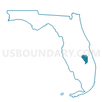
P10-Voting District, Okeechobee County, Florida
About
Outline

Summary
| Unique Area Identifier | 556927 |
| Name | P10-Voting District |
| County | Okeechobee County |
| State | Florida |
| Area (square miles) | 216.15 |
| Land Area (square miles) | 213.36 |
| Water Area (square miles) | 2.78 |
| % of Land Area | 98.71 |
| % of Water Area | 1.29 |
| Latitude of the Internal Point | 27.48631330 |
| Longtitude of the Internal Point | -80.78391950 |
Maps


Graphs
Select a template below for downloading or customizing gragh for P10-Voting District, Okeechobee County, Florida


Neighbors
Neighoring Voting District (by Name) Neighboring Voting District on the Map
- 28-Voting District, St. Lucie County, FL
- 29-Voting District, St. Lucie County, FL
- 308B-Voting District (Central Portion of 308), Indian River County, FL
- 308C-Voting District (Western Portion of 308), Indian River County, FL
- 31-Voting District, St. Lucie County, FL
- 89-Voting District, Osceola County, FL
- P01-Voting District, Okeechobee County, FL
- P02-Voting District, Okeechobee County, FL
- P07-Voting District, Okeechobee County, FL
Top 10 Neighboring County Subdivision (by Population) Neighboring County Subdivision on the Map
- Fellsmere CCD, Indian River County, FL (19,591)
- North Okeechobee CCD, Okeechobee County, FL (8,591)
- South and East Osceola CCD, Osceola County, FL (7,194)
- West St. Lucie CCD, St. Lucie County, FL (6,145)
Top 10 Neighboring Unified School District (by Population) Neighboring Unified School District on the Map
- St. Lucie County School District, FL (277,789)
- Osceola County School District, FL (268,685)
- Indian River County School District, FL (138,028)
- Okeechobee County School District, FL (39,996)
Top 10 Neighboring State Legislative District Lower Chamber (by Population) Neighboring State Legislative District Lower Chamber on the Map
- State House District 79, FL (187,203)
- State House District 29, FL (160,290)
- State House District 78, FL (156,153)
- State House District 80, FL (148,503)
Top 10 Neighboring State Legislative District Upper Chamber (by Population) Neighboring State Legislative District Upper Chamber on the Map
Top 10 Neighboring 111th Congressional District (by Population) Neighboring 111th Congressional District on the Map
- Congressional District 15, FL (813,570)
- Congressional District 16, FL (797,711)
- Congressional District 23, FL (684,107)
Top 10 Neighboring Census Tract (by Population) Neighboring Census Tract on the Map
- Census Tract 509.04, Indian River County, FL (7,218)
- Census Tract 438, Osceola County, FL (7,194)
- Census Tract 3822, St. Lucie County, FL (6,145)
- Census Tract 9101.01, Okeechobee County, FL (5,770)
- Census Tract 9101.02, Okeechobee County, FL (2,821)